
Navigation Limits and Levels
The Lower and Upper Avon is navigable over 46 miles (74km), with 17 locks along it’s course, from Tewkesbury to Alveston weir above Stratford-upon-Avon.
Map of the Lower Avon from Tewkesbury to Evesham
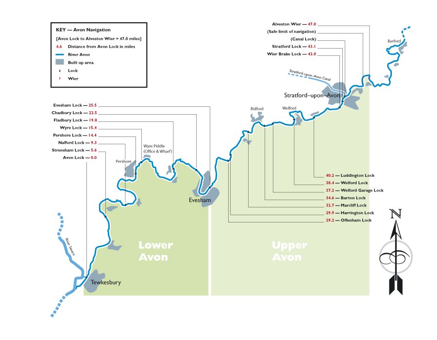
Map of the Upper Avon from Evesham to above Stratford-upon-Avon
The River Avon, has junctions with the Stratford Canal at the top of the navigation, and the River Severn at the bottom, and forms part of a navigable ‘ring’ that includes the Worcester and Birmingham Canal. For more information, see Links.
Maximum Recommended Craft Dimensions
Stated maximum draught is for vessels with protected sterngear. Note that minimum headroom is at normal river levels, and can be lower during periods following heavy rain.
| Lower Avon | Upper Avon | |||
| Length | 70ft | (21.3m) | 70ft | (21.3m) |
| Beam | 13ft 6in | (4.1m) | 12ft 6in | (3.8m) |
| Draught | 4ft | (1.2m) | 3ft | (0.9m) |
| Headroom | 10ft | (3.0m) | 8ft | (2.4m) |
River Levels and Gauges
Unlike a canal, the water in a river is continually flowing, and its rate of flow and level varies. After heavy rain in the catchment area, levels can rise, and/or the rate of flow increase to a point where navigation can be hazardous.
The Trust has installed water level gauges at every lock designed to indicate the water level in each stretch of the river and help you gauge whether it is safe to proceed. Check the water level against the colours on the gauge, and compare it with the advice on the sign.