Navigation Information & Shop

The Warwickshire River Avon is navigable over 47 miles, with 17 locks along its course, from Alveston weir above Stratford-upon-Avon, through Warwickshire, Worcestershire and Gloucestershire to where it joins the River Severn at Tewkesbury.

The River Avon, has junctions with the Stratford Canal at the top of the navigation, and the River Severn at the bottom, and forms part of a navigable ‘ring’ that includes the Worcester and Birmingham Canal. We have available to order online The River Avon Visitor Guide, The Little ANT Book of River Poems, pump out waste tokens, fishing permits plus free to download maps and information leaflets. These items as well as more gifts and information are also available at the River Avon Welcome Centre

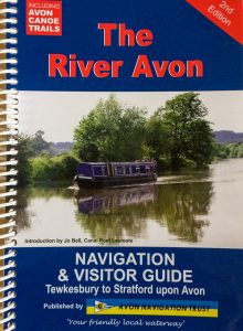
The River Avon Navigation and Visitor Guide

We highly recommended that you purchase the ANT River Guide.

This is a great guide book that has loads of information about the river, details (including pictures and drawings) of each lock and all the moorings as well as maps of the complete navigation. Everything you need to plan your trip and help you feel at ease. Post to UK only

Every Boat should have one ! 

All proceeds go direct to the charity to help in its work. 

Click here to order your ANT Navigation and Visitor Guide. 

Buy Guide

General Information


Maximum Recommended Craft Dimensions

Stated maximum draught is for vessels with protected sterngear. Note that minimum headroom is at normal river levels, and can be lower during periods following heavy rain.

   Lower Avon  Upper Avon
Length   70ft  (21.3m)       70ft  (21.3m)
Beam   13ft 6in  (4.1m)       12ft 9in  (3.89m)
Draught   4ft  (1.2m)       3ft  (0.9m)
Headroom   10ft  (3.0m)       8ft  (2.4m)


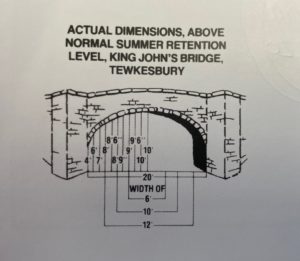
King Johns Bridge can be used as a gauge for headroom on the Avon from Tewkesbury to Evesham. Click here to see large diagram
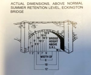


Eckington Bridge Headroom and Width


River Levels and Gauges

Unlike a canal, the water in a river is continually flowing, and its rate of flow and level varies. After heavy rain in the catchment area, levels can rise, and/or the rate of flow increase to a point where navigation can be hazardous.

The Trust has installed water level gauges at every lock designed to indicate the water level in each stretch of the river and help you gauge whether it is safe to proceed. Check the water level against the colours on the gauge, and compare it with the advice on the sign.

RED         Danger – stop and moor your boat.

ORANGE   Increased current, proceed with caution.

GREEN     Normal navigable level.

The Trust has also set up River Watch, which is a network of web cams and links to the EA river gauges that can be viewed through our web site on your PC or smart phone. Please view this on our River Watch Page.


Locks

There are 17 locks on the 47 miles of the Avon between Tewkesbury and Stratford.

Locks on the Avon are manually operated by boaters, and the paddle gear on the locks accept the small 1in taper (or the ‘Northwich’ type lock key) on your  windlass.

The exception is Avon lock at Tewkesbury, which is manned by a lock keeper.

Avon Lock  – Lock keeper’s hours for 2024 are:

1st January to Friday 15th March 2024:  Booked passage only

Saturday 16th March to Sunday 3rd November 2024:  8:00am to 18:00

Monday 4th November 2024 to Friday 14th March 2025: Booked passage only

(lunch break:  1300 – 1400. Last Locking 1pm)


Operating Locks Winter – Avon Lock at Tewkesbury is un-manned and bookings for an out of season locking can be requested by calling the office on 01386 552517 or 0300 111 2010 – 48 hour prior to passage.

If you have not operated locks before, don’t worry. Take your time, and if you are unsure ask another boater – they will be happy to help. Passing through locks in company eases the load, and allows you to chat to other people on the river.

When locking up to a higher level, secure lines at bow and stern but be prepared to take in the slack as the boat rises, inside the lock with both bow and stern lines, close the gates and check their paddles are lowered, or closed. Go to the top gates and operate the rack gearing to raise the paddles. Open them a little way at first and pause; the turbulence from too much water entering the chamber can force boats off the lock side, or make them surge up and down and hit the gates. Once the water level has risen a little, and crews have shortened in their lines, open the paddles some more, check all is safe and then you should be able to open them up fully. Leave the gates OPEN when you leave, and all paddles CLOSED. When closing the paddles, please wind them down slowly; pushing down the rack with your hand causes shock loading and can damage the gear and equipment.

When locking to a lower level, the procedure is the same, except for the following. Boat crews MUST NOT make fast their lines, but should pay them out by hand as the water level in the lock drops. Vessel’s should KEEP CLEAR of the cill below the top gates to avoid being caught up on their sterngear. Operators of the paddles on the bottom gates should be vigilant, and close them immediately if a vessel gets into difficulties.

** Please use both a bow and stern line at all times. Centre lines are not acceptable on the river. **


Rights of Way

In common with maritime convention, the rule is to pass port to port (meaning you should ‘drive on the right’ or alter course to starboard to pass another boat). You should give way to commercial, cargo carrying vessels and maintenance craft, and they should be given priority at locks. If your vessel is large or difficult to manoeuvre, please give one long blast on your horn when negotiating a sharp or blind bend in the river to warn other river users you are approaching.

Speed

The maximum speed limit on the Avon is: maximum speed limit is 4mph upstream and 6mph downstream (measured over the river bed). Please slow down when approaching bridges, locks, blind corners, and narrow sections of the river, or when passing moored craft.

Wash

The wash produced by a boat not only depends upon it’s speed, but also it’s hull form and how it is laden. Excessive wash from boats damages and erodes the riverbank. If your vessel is producing a large wash, please slow down. Please always slow down when passing moored boats or other river users.

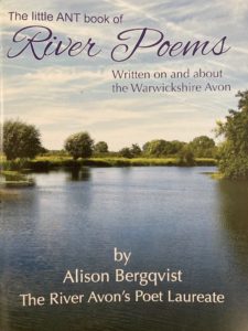
The Little ANT Book of River Poems by Alison Bergqvist.

Written on and about the Warwickshire Avon by our sparkling new Poet Laureate.

Immerse yourself in a wonderful world of verse inspired by Avon and nature loving Alison’s experiences of boating on one of the prettiest rivers in the country. 

Enjoy 20 glorious poems and Alison’s fine photographs in a must-have book that also raises money for ANT’s work on the River that moves so many of us. 

As our Bard of the Avon says: “She makes my heart sing, this living thing”. 


Buy The Little ANT Book of River Poems


Avon Navigation – Welcome Information Leaflet (Free)

Useful information of the services and facilities available along the river, together with navigation safety information is covered in the Welcome Information Leaflet. 


Free Welcome Information Leaflet

Sanitary Station Pump out Machines

ANT Sanitary pump out tokens

Pump out tokens

The Trust Sanitary Station pump out machines are located at Pershore King Georges Field and Evesham Lock. To operate the machine you will need a token for each pump out. These can be purchased at Avon Lock Tewkesbury, Angel Hotel Pershore, Pershore Town Hall, The Almonry Heritage Centre Evesham and River Avon Welcome Centre (RAWC) normally moored at Avon Lock Tewkesbury or you can purchase on line to be posted to you. UK only.


Buy Pump-out tokens
Waterway Routes

FREE ELECTRONIC MAPS


FREE RIVER AVON MAPS


ANT have joined forces with Waterways Routes and we are covering their costs to make their River Avon maps FREE OF CHARGE.

The maps can be downloaded instantly in a choice of two formats.  Clear presentation shows the Locks, bridges, and other features superimposed on an Ordnance Survey (OS) background map. Icons represent all the facilities, including moorings and their time limits.


Acrobat (pdf) format maps are split into A4 pages ready for viewing on screen or printing yourself using the freely available Adobe Acrobat Reader software or App


Memory-Map (qct) format maps have the same map pages joined into one large scrollable and zoomable map.  This works with the GPS on a phone or tablet like sat-nav.  This works on Android, iPhone/iPad, Windows and Mac with the Memory‑Map software or app installed, and the classic map compatibility option enabled.  Although the map is free to download, Memory-Map may charge you for the Software or App.


Visit Waterway Routes website for the free River Avon Map.


FREE River Avon Maps


DISCOUNTED AVON RING MAPS

We have also worked with Waterway Routes to reduce the price of their Avon Ring maps which are great value if you are cruising around the ring.

Visit Waterway Routes website for the discounted Avon Ring Map.


Discounted Avon Ring MAPS

DISCOUNTED AVON RING DVDs


Waterway Routes also produce DVDs of the Avon Ring in a choice of two formats which are great for planning your journey or showing family or friends where you have been.  They also make ideal gifts.

We have worked with Waterway Routes so you get a 10% discount on these too


Discounted Avon Ring DVDs

Fishing at Luddington Weir Island

Avon Navigation Trust own the fishing rights for Luddington Weir Island. From here there is good fishing for roach, perch, bream and large chub. You may fish above or below the weir but not in the navigation channel, the lock landing stages or moorings. Patrols operate regularly, so please print off your permit or save it on your mobile device for inspection. You will also need to have an Environment Agency Rod Licence Access to the lock is through the pedestrian gate from Luddington. 

Day permits are £5.00 and Season permits are £40.00 and can by clicking the button below

Fishing Permits

Video Vlog of River Avon

See videos of trips along the Avon in our Video Library